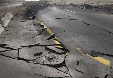
Know if you live in these earthquake-prone districts and how to prepare yourself
The year 2020 has been a year of challenges. Amid the Coronavirus pandemic, locust swarms and cyclone various Indian cities are now experiencing earthquake tremors. There have been many Earthquake tremors felt recently in cities like New Delhi, Gurugram, Leh and many cities in Gujarat and north-east India. You can check the last 30-day history of earthquakes in India here.
As much as we would love not to worry, these recent earthquakes surely do not provide any comfort to not think about it. The best that we all do at this point is to learn if we are in one of the troubled zones and be at an alert and prepare.
Know the quake better
The Richter magnitude scale (developed by Charles Richter) is a scale of numbers used to tell the power (or magnitude) of earthquakes. Earthquakes 4.5 or higher on the Richter scale can be measured all over the world and any earthquake below 4.5 (on the Richter scale) doesn’t do much damage. However, the Richter scale is a logarithmic scale i.e., an earthquake of reading 5 is about 10 times the amplitude of one that reads 4.0 on the scale. An earthquake at a scale of 5 has seismic energy that can be equated to that of the Nagasaki atomic bomb.
Strong earthquakes: A moderate earthquake registers between 5 and 5.9 on the Richter scale and causes slight damage to buildings and other structures. About 500 such earthquakes are registered every year around the globe. Strong earthquakes that can cause a lot of damage are the ones that measure 6.0+ on the Richter scale. The strongest ever earthquake was in Chile in 1960 that had a magnitude of 9.5 on the Richer scale.
Who monitors earthquake activity in India: This is done by the National Centre for Seismology (NCS). As per NCS, more than a dozen Indian cities are termed as high risk that can face major casualties. 59% of the Indian subcontinent is vulnerable to earthquakes. According to a report, casualties due to earthquakes take a bad shape because our buildings are not designed to be quakeproof.
What are seismic Zones? Based on the seismic activity, the Bureau of Indian Standards (BIS) has divided the entire country into Zones i.e. Zone II – Zone V. Zone II is considered the least seismically active, while Zone V is the most active. Zone IV and V fall under “severe” to “very severe” categories respectively.
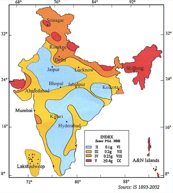
Zone V Districts
Zone 5 covers the areas with the highest risk that suffer earthquakes of intensity MSK IX or greater. Following are the districts (state-wise) that fall under this Highest Risk zone.
| ANDAMAN & NICOBAR ISLANDS | Andamans, Nicobars (2) |
| ARUNACHAL PRADESH | Lower-Subansiri, Tawang, Tirap, Upper-Siang, Upper-Subansiri, Changlang, Dibang-Valley, East-Kameng, East-Siang, Lohit, Papum-Pare, West-Kameng, West-Siang (13) |
| ASSAM | Dhubri, Cachar, Hailakandi, Karimganj, North-Cachar-Hills, Barpeta, Bongaigaon, Darrang, Upper-Dhemaji, Dibrugarh, Goalpara, Golaghat, Jorhat, Kamrup, Karbi-Anglong, Kokrajhar, Lakhimpur, Marigaon, Nagaon, Nalbari, Sibsagar, Sonitpur, Tinsukia (23) |
| BIHAR | Araria, Darbhanga, Kishanganj, Madhepura, Madhubani, Purnia, Saharsa, Sitamarhi, Supaul, Muzaffarpur (10) |
| GUJARAT | Kachchh (1) |
| HIMACHAL PRADESH | Solan, Una, Bilaspur, Chamba, Hamirpur, Kangra, Kullu, Mandi (8) |
| JAMMU & KASHMIR | Anantnag, Baramula, Pulwama, Srinagar, Badgam, Kathua, Kupwara, (7) |
| MANIPUR | Bishnupur, Chandel, Imphal-East, Thoubal, Ukhrul, Churachandpur, Imphal-West, Tamenglong, Senapati (9) |
| MEGHALAYA | Jaintia-Hills, East-Garo-Hills, East-Khasi-Hills, Ri- Bhoi, South-Garo-Hills, West-Garo-Hills, West-Khasi-Hills (7) |
| MIZORAM | Aizawl, Champai, Kolasib, Lawngtlai, Lunglei, Mamit, Saiha, Serchhip (8) |
| NAGALAND | Phek, Zunheboto, Dimapur, Kohima, Mokokchung, Mon, Tuensang, Wokha (8) |
| TRIPURA | Dhalai, North-Tripura, South-Tripura, West-Tripura (4) |
| UTTARANCHAL | Almora, Bageshwar, Chamoli, Pithoragarh, Rudraprayag, Tehri-Garhwal Uttarkashi, Garhwal (8) |
| WEST BENGAL | Jalpaiguri, Koch-Bihar (2) |
Zone IV Districts
Zone IV is called the High Damage Risk Zone and the following districts (state-wise) fall under this zone.
| BIHAR | Banka, Begusarai, Bhagalpur, Bhojpur, Gopalganj, Jehanabad, Katihar, Khagaria, Lakhisarai, Munger, Nalanda, Purba-Champaran, Pashchim-Champaran, Patna, Samastipur, Saran, Siwan, Vaishali, Nawada, Sheikhpura, Jamui; Sheohar (22) |
| CHANDIGARH | Chandigarh (1) |
| DELHI | East, South, Central, New Delhi, North, North-East, North-West, South-West, West (9) |
| GUJARAT | Banas-Kantha, Jamnagar, Patan, Rajkot (4) |
| HARYANA | Ambala, Faridabad, Gurgaon, Panchkula, Rewari, Yamunanagar Bhiwani, Mahendragarh Jhajjar, Karnal, Kurukshetra, Panipat, Rohtak, Sonipat (14) |
| HIMACHAL PRADESH | Sirmaur, Kinnaur, Lahul-Spiti, Shimla (4) |
| JAMMU & KASHMIR | Doda, Jammu, Punch, Rajauri, Udhampur, Leh-(Ladakh), Kargil (7) |
| JHARKHAND | Godda, Sahibganj (2) |
| MAHARASHTRA | Kolhapur, Pune, Raigarh, Ratnagiri, Sangli, Satara (6) |
| PUNJAB | Amritsar, Fatehgarh-Sahib, Gurdaspur, Hoshiarpur, Jalandhar, Kapurthala, Ludhiana, Nawanshahr, Patiala, Rupnagar Moga, (11) |
| RAJASTHAN | Alwar, Barmer, Bharatpur, Jalor, (4) |
| SIKKIM | East, South, North, West (4) |
| UTTAR PRADESH | Aligarh, Baghpat, Bahraich, Ballia, Balrampur, Bareilly, Basti, Bijnor, Budaun, Bulandshahar, Deoria, Etah, Gautam-Buddha- Nagar, Ghaziabad, Gonda, Gorakhpur, Hathras, Jyotiba Phule Nagar, Kheri, Kushinagar, Maharajganj, Mathura, Meerut, Moradabad, Muzaffarnagar, Pilibhit, Rampur, Saharanpur, Sant Kabir Nagar, Shahjahanpur, Shravasti, Siddharthnagar (32) |
| UTTARANCHAL | Nainital, Udhamsingh-Nagar, Hardwar, Dehradun, Champawat (5) |
| WEST BENGAL | Uttar-Dinajpur, North-24-Parganas, South-24- Parganas, Darjiling, Dakshin-Dinajpur, Maldah (6) |
Why is a large part of India vulnerable to earthquakes?
Reports suggest at 50 million years ago Indian subcontinent’s tectonic plates collided with Eurasia. Before this incident, Indian tectonic plates had been shifting at the rate of 18cm per year. This is considered to be a very high speed by geologists. The effect of India crashing with Eurasia created the Himalayan Mountain Range and also slowed down the drifting, but could not stop it. Today it continues to shift at the speed of 2 cm per year which is the primary cause for high seismic activity in a large part of the country.
How To Mitigate The Risk?
Multiple factors affect the vulnerability of the city and a building. Almost 90% of casualties due to earthquakes, that have struck India, have been due to building collapses. Unregulated and rapid pace construction in Indian cities has now posed a higher risk as these are not well-planned buildings with no safety codes.
Factors like building projection, the spacing between two buildings, soil conditions, foundations and construction material quality play a vital role. You may visit the website of Building materials & Technology Promotion Council to learn about building materials to be used in Zone V and Zone IV districts.
Is there a reason to worry and how to prepare for an earthquake?
In the wake of recent earthquakes in the NCR region, while some geologists have raised concerns about these smaller shakeups being a warning for a bigger earthquake that might hit us, most other scientists have said that there is no need to panic but we should be prepared. You might want to check this earthquake preparedness guide by the National Institute of Disaster Management (NIDM).
Stay informed and stay safe folks!